FastWind: Satellite Derived Offshore Wind, Made Simple, major project milestone reached.
Share
Exceedance are excited to share a major milestone in the FastWind project — a powerful new tool that’s transforming how offshore wind projects get off the ground. As we approach the end of the pilot phase our data validation has exceeded expectations, showing exceptionally low error and bias against real-world measurements.
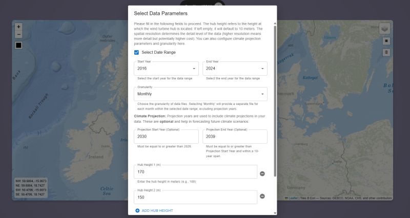
With FastWind, you can now click anywhere offshore and instantly access long-term, satellite-derived measured wind data at hub height — fast, accurate, and incredibly easy to use. No satellite expertise or complex data processing required and it links automatically to our financial modelling software.
A cloud-based web interface makes the user experience smooth and intuitive.
The results plug straight into Exceedence Ltd exfin Software for fast, confident financial modelling.
As far as we know, FastWind is the only tool available globally offering this level of offshore wind data in such a user-ready format linked directly to financial models.
We’ve also added the ability to include climate projections, helping developers and planners understand how wind resources might shift over the coming decades — a key insight for long-term infrastructure planning and risk management.
The project is nearing the end of its pilot phase, and early results show huge promise for accelerating offshore wind development worldwide.
Our brilliant partners at NORCE Research have taken the lead on validating the satellite data and published more detail here https://lnkd.in/edBX5JfK and with special thanks to Ørsted for providing data and Simply Blue Group for partnering and driving the requirements.
We’re proud to be delivering this work with the support of the European Space Agency - ESA as part of their ARTES 4.0 Business Applications – Space Solutions.
Explore the full project: https://lnkd.in/eZRuyn7H