20-year INFOMAR survey of Irish seabed coming into final lap
Share
17/02/2025- Source RTE news
The INFOMAR programme which has been compiling an in-depth survey of the Irish seabed undertaken over the last 20 years is coming to its last lap.
By using sonar to produce maps, it aims to make navigation safer and increase the opportunity for development of the marine area. The survey will also allow Ireland to claim extra territorial waters.
Aileen Bohan, a hydrographer from the Geological Survey of Ireland who is part of the survey, said that under the UN Convention on the Law of the Sea, countries are allowed to claim more seabed if it can be shown to be the same geological feature as in existing territorial waters.
She said this can be used to expand a country's exclusive economic zone from 200 nautical miles to 350 nautical miles. The seabed information can be used for aquaculture, marine heritage, off-shore renewable energy and fishery research.
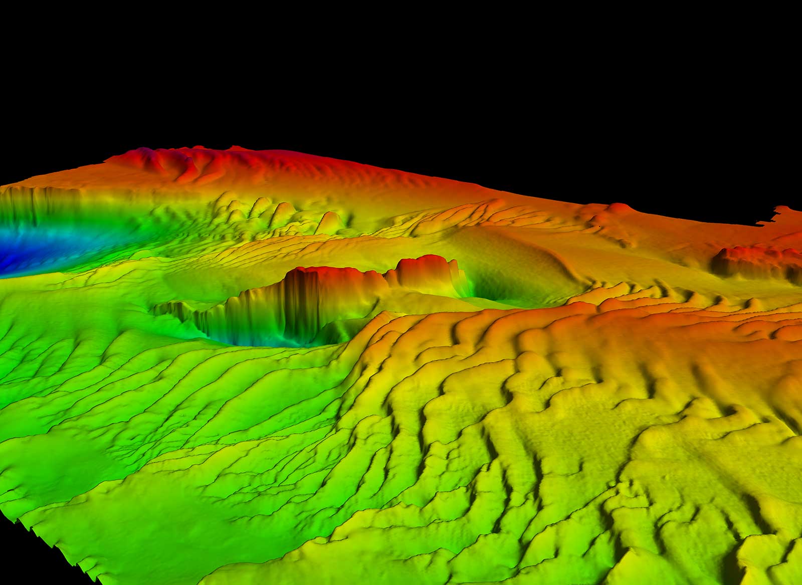
Traditional maritime maps were drawn up by dropping lead lines into the sea to gauge depths. What they were able to achieve was incredible, Ms Bohan said, but added that "ultimately, these are spot soundings. So, you imagine that you could miss boulders, you could miss parts.
"By using the multi-beam echo sounder, we can actually send sound signals at the whole seabed and come up with a full 3D imagery of the seabed."
Irish Shipwrecks
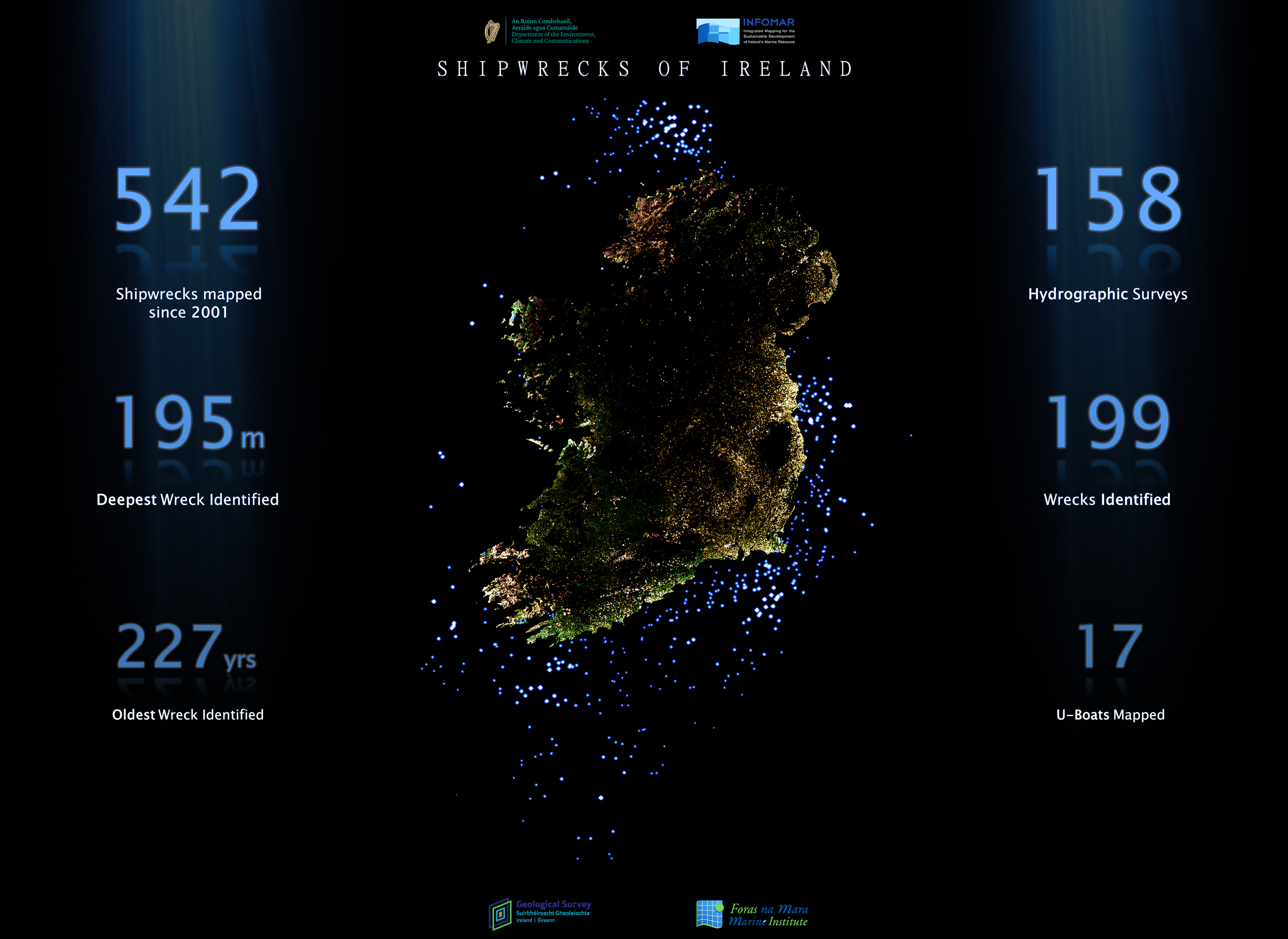
The INFOMAR survey also identifies shipwrecks and maps their location.
Athlone Sub-Aqua Club search and recovery officer; Liam Sheringham said they had been searching for years for the wreck of the MY Roussalka in the sea off Killary fjord, but were unable to locate it.
"We contacted INFOMAR. A couple of months later, I received an email stating that they had found the wreck here in Killary, and they kindly passed on a side scan image of the wreck on the coordinates to us in the club," he said.
The Roussalka had a number of connections to world history. Originally named the SS Brighton, it was used as an ambulance ship during World War I and to bring US President Woodrow Wilson back to England after peace talks in France at the end of the war. Walter Guinness then bought it and used it to travel around the world, but it came to grief in Killary in 1933 because of a missing detail in the maritime maps of the time.
Historian Kevin Egan said it has been shown that the Roussalka had hit an uncharted rock in the bay which had not been picked up before.
"This is quite surprising, considering that the Royal Navy were very well acquainted with those waters, having sailed throughout them many, many times," he said.
Walter Guinness was later appointed Minister for the Middle East by Winston Churchill but was assassinated by Jewish extremists in Cairo in 1944.
Meanwhile the INFOMAR survey, which is a joint study between the Geological Survey Ireland and the Marine Institute and funded by the Department of the Environment, is due to finish its work next year.
RTÉ Nationwide will include more on the INFOMAR programme on RTÉ One at 7pm tonight 17th February 2025
About INFOMAR
INFOMAR is a DECC funded joint programme between the Geological Survey Ireland and the Marine Institute, surveying our unmapped marine territory and creating a range of integrated mapping products of the physical, chemical and biological features of the seabed.